


For the past five years, whenever high-density housing has been proposed in Rockridge and neighbors have pushed back with proposed modifications and concerns, supporters of the developer’s plans have quickly and vocally labeled the Rockridge neighborhood as both “racist” and “elitist.”

Political Labels and Historical Context
This is a well-known political smear tactic, often used to discredit the opposition. The tactic is employed to label those in opposition as morally repugnant and self-serving in order to silence them and deprive them of a voice.
Racial Exclusion Shaped Housing Development and Access
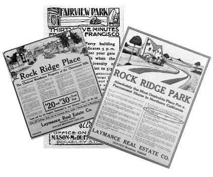
To be clear, the Rockridge Park development’s history of racial exclusion dating back to 1906 is absolutely not uniquely racist. Indeed, a good argument can be made that no one who has grown up in America has grown up in a place free of the systemic racism that has been directed at both non-White and non-Christian minorities for centuries here.
Although the Fair Housing Act prohibited racial and religious housing discrimination in 1968, discrimination continued. (See the article “Before the Labels: The Historical Context of Neighborhood Zoning” for details.)
Zoning Changes of 1974
It has recently become a meme that Rockridge downzoned in 1974 for racist reasons. This concept is a prime example of what happens when history is viewed through the lens of ideology without historical context and facts. Let’s look at the timeline:
1952: Freeway Re-Routed from Berkeley to North Oakland
The City of Berkeley changed the route of the planned connector freeway being planned to join Highway 24 to Interstate 80. The original route ran through Berkeley, down State Highway 13 (also known as Ashby Avenue) and was instead moved to North Oakland. This change included locating the BART station from Telegraph and Ashby Avenues to College Avenue.
1964–1969: The Great Housing Destruction & De-Population
During a 5-year period, 1,400 mostly historic Craftsman homes were removed and the land cleared for the construction of Highway 24 and BART. It is estimated that between 3,000 and 5,000 residents were forced to leave as a result.
1964–1973: Nine Years of Construction and Neighborhood Destruction
The Loss of the Temescal Creek Watershed
The first casualty was the pristine ecosystem of the middle fork of Temescal Creek, which ran almost totally free from Lake Temescal to just above College Avenue, through the Temescal Canyon.
The wild creek, which had once been the favorite subject of the famous plein air painters of the Society of Six, many of whom lived in Rockridge, was culverted, and the canyon leveled and obliterated.
The slope of Highway 24 from the Caldecott tunnels to the College Avenue exit is the only evidence left of the beautiful Temescal Canyon ecosystem that once flowed freely. It had been blocked when Anthony Chabot dammed it for drinking water, the only drinking water for North Oakland… and had it stocked with trout.
Catastrophic Damage to College Avenue Businesses
The second casualty was the College Avenue business district, once one of the most vibrant business districts in Oakland. The elevated route of Highway 24 bisected College Avenue and left gaping holes along the avenue that were used for corporation equipment yards.
Over half of all businesses on College Avenue were closed, with many other buildings boarded up. The loss of their thousands of customers who had lived in the 1,400 demolished homes was catastrophic when combined with the difficulty of navigating around the local road closures surrounding the disrupted main street.
The Toll on Residents
The third casualty was the remaining residents of the Chimes neighborhood, who were severely affected and traumatized by the daily destruction of their neighborhood over a period of many years.
BART resurrected the name “Rockridge” from the 1909 development of the same name above Broadway. The neighborhood had no say in the matter. (See the article “Before the Labels: The Historical Context of Neighborhood Zoning.”) The elevated freeway construction brought constant noise, air pollution, and particulate pollution. The completed freeway has continued to spew air and noise pollution over the neighborhood, as well as particulates from brake dust and tire dust, for more than 50 years now.
Crime and the Origins of Neighborhood Watch
The final casualty was any sense of personal safety of the neighborhood’s remaining residents. From the late 1960s until the early 1970s, the neighborhood had the highest crime rate in the city—resulting in commercial and residential property values falling to unprecedented lows. The one saving grace was that these lowered property values allowed many young people the opportunity to buy homes here.
In response to the rise in crime, Rockridge neighbors pushed back vigorously by forming block groups and telephone trees to watch out for each other. The model they developed was the foundation of the organized citizen crime-fighting effort that would come to be known and adopted internationally as “Neighborhood Watch.”
1972: New Commercial and Residential Zoning
Rockridge residents, in partnership with the College Avenue Merchants Association (now the Rockridge District Association), developed a plan to revitalize College Avenue through zoning changes. The existing commercial zoning was very car-centric and allowed large setbacks from the sidewalk, as well as large surface-area parking lots.
Residents proposed new pedestrian-oriented zoning that required shops to have sidewalk-facing windows, no large surface parking lots, and established design requirements that would promote a walkable commercial environment.
This was the first non-car-centric zoning in Oakland and was designated C-31. In time, five other commercial districts in Oakland adopted the C-31 (now CN-1) zoning with great commercial success.
In addition, Rockridge pioneered a new commercial-to-residential “buffer zone” that was designated R-35, a moderate-density residential zone comprising a one-block-deep strip on both sides of College Avenue between the single-family residential R-30 and the commercial C-31 zones.
The success of the Rockridge commercial district is directly attributable to the zoning changes of 1972. In the 54 years since, College Avenue in Rockridge has almost always occupied first place among the City of Oakland’s economic engines, occasionally even outperforming the old Broadway Auto Row in tax revenues.
1973: BART’s High-Density Development Proposal
BART’s high-density development proposal for transit stations was envisioned as a mini-downtown or mixed-use transit village with a quarter-mile radius around the Rockridge station. The proposed high-rise, high-density residential towers would necessitate the demolition of many more existing homes for housing towers that were unprecedented anywhere in Oakland outside of Lake Merritt where the first high-rise in Oakland was the 25-story apartment building at 1200 Lakeshore, built in 1968.
After years of collective trauma, residents were done being test subjects for plans that ignored their needs or desires, and they organized in strong opposition to any additional demolition or destruction of their neighborhood. A nascent Rockridge Community Planning Council (RCPC) decisively secured the down zoning of College Avenue to a 35-foot height limit, which led to future zoning initiatives.
Lasting Effects on Rockridge and West Oakland
It should be noted that at the time, the City of Oakland did little if anything to help its residents or merchants of Rockridge recover from the years of adverse effects from the construction of Highway 24 and BART.
In all, only two neighborhoods of Oakland were subjected to this widespread destruction of a community: West Oakland and Rockridge. West Oakland got the worst of it by far when the freeway was built directly through their downtown, dividing the neighborhood and additional freeway connections, cutting it off from the rest of Oakland.
During that period, West Oakland lost much of the thriving Seventh Street business and entertainment district that had earned it the name “Harlem of the West Coast,” as freeway, BART, and postal-facility construction displaced Black-owned businesses, hotels, and entertainment venues.
Both neighborhoods were considered expendable by the Republican political machine that ran Oakland during that period because they were lower-income communities and/or predominantly populated by racial minorities. It was the era of “urban removal” at its most ambitious and vicious.
The success of Rockridge is no accident, it took years of community activism to recover from the destruction brought by the construction of Hwy 24 and BART and to create the thriving and desirable district it has become today. An honest debate about the impact of new highrise construction in Rockridge must acknowledge what its residents endured, take into account how that history influenced current efforts to protect our neighborhood, and what we want to see moving forward.


